

 Skip to content

AI Image Generator for Earth Observation: Flypix AI Unlocks Insights from Aerial & Satellite Data
AI image generator technology like Flypix AI is revolutionizing how we analyze aerial and satellite imagery. Flypix AI empowers users to create powerful AI use cases without needing any expertise in machine learning or generative AI. Its intuitive platform allows you to detect objects, segment land cover, and extract valuable insights from Earth observation data. With Flypix AI, automation becomes seamless, saving time and resources while providing accurate and efficient analysis for a wide range of applications, from urban planning to environmental monitoring.
Pricing
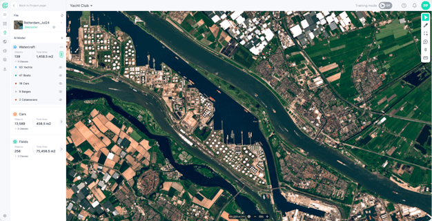
This is a detailed description of the FlyPix platform, a geospatial AI platform for analyzing Earth's surface. Here's a breakdown of what it offers: Core Functionality: AI-Powered Object Detection and Analysis: FlyPix uses advanced algorithms to identify and outline objects within geospatial images (satellite imagery, aerial photography, etc.). This allows users to analyze complex scenes efficiently. Custom Model Training: Users can train their own AI models to detect specific objects relevant to their needs. The platform simplifies this process, making it accessible even without deep AI expertise. User-defined annotations guide the model training. Key Features: Interactive Sandbox: Users can experiment with FlyPix's capabilities through an interactive sandbox environment. Time Savings: FlyPix drastically reduces the time spent on manual object annotation compared to traditional methods, potentially saving up to 99.7% of the time. Scalability: The platform handles large datasets and complex scenes effectively. Multispectral Data Support: FlyPix can process multispectral imagery, providing additional layers of information for analysis. Pricing and Plans: FlyPix offers a tiered pricing structure with various plans: Free Tier: Includes limited storage (3GB), 10 credits, and access to basic features. Starter Plan: Offers more storage (10GB), 50 credits, processing capabilities up to 1 gigapixel, and additional features like collaboration tools. Standard Plan: Provides even more storage (120GB), 500+100 credits, processing up to 12 gigapixels, faster support, and advanced features. Professional Plan: Includes extensive storage (600GB), 2,000+1,000 credits, processing up to 60 gigapixels, priority support, API access, expert GIS assistance, white-label options, and multispectral data capabilities. Enterprise Plan: Customized solutions tailored to the specific needs of large organizations. Industries Served: FlyPix caters to a wide range of industries, including: Construction Agriculture & Farming Renewable Energy Oil & Gas Smart City Development Overall Impression: FlyPix appears to be a powerful and versatile geospatial AI platform designed for efficient object detection, analysis, and custom model training. Its user-friendly interface, various pricing tiers, and support for diverse industries make it an attractive solution for organizations seeking to leverage the power of AI in their geospatial workflows.
Customizable/Quote-Based


How would you rate Flypix AI?